Back Luchent AN Llutxent AST Llutxent Catalan Лученте CE Llutxent (munisipyo) CEB Llutxent German Llutxent DIQ Luchente Spanish Llutxent Basque Llutxent French
Llutxent | |
|---|---|
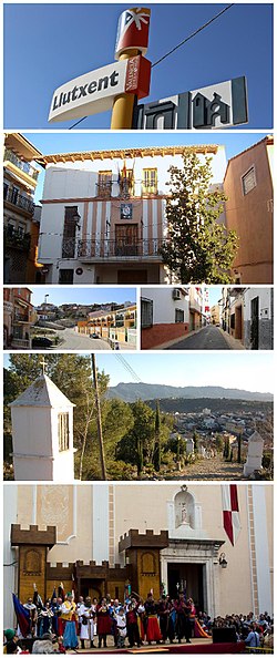
 Clockwise: Llutxent's info-sign, Town hall building, Del Mig Street, View from top of The Coast, Town's Main Square during Moors and Christians, Montsant avenue | |
| Nickname: Llutx | |
| Coordinates: 38°56′33″N 0°21′23″W / 38.94250°N 0.35639°W | |
| Country | |
| Autonomous community | |
| Province | Valencia |
| Comarca | Vall d'Albaida |
| Judicial district | Ontinyent |
| Government | |
| • Alcalde | Pep Estornell Català (Unity for Llutxent) |
| Area | |
| • Total | 40.1 km2 (15.5 sq mi) |
| Elevation | 280 m (920 ft) |
| Population (2018)[1] | |
| • Total | 2,373 |
| • Density | 59/km2 (150/sq mi) |
| Demonym(s) | Llutxentine llutxentí, -ina (va) |
| Time zone | UTC+1 (CET) |
| • Summer (DST) | UTC+2 (CEST) |
| Postal code | 46838 |
| Official languages | Valencian and Spanish |
| Website | Official website |
Llutxent (Valencian pronunciation: [ʎuˈtʃent]) is a town located in the eastern part of Spain, in the Valencian Community, within the comarca of the Vall d'Albaida, 80 km south of Valencia and 110 km north of Alicante.[2] As of 2016, it is inhabited by 2,402 people.[3]
The town's economy is based on agriculture, construction, transport and the manufacture of pallets, and a small services sector.[4]
The town was first settled by Ancient Romans.[5]
Llutxent is host to one of the most popular Moors and Christians celebrations during the end of April, attracting many people around the Valencian Community to see the festival.[6]
- ^ Municipal Register of Spain 2018. National Statistics Institute.
- ^ "On estem?". Ajuntament de Llutxent (in Catalan). 2015-07-23. Retrieved 2018-04-27.
- ^ "Instituto Nacional de Estadística. (Spanish Statistical Institute)". www.ine.es (in Spanish). Retrieved 2018-04-27.
- ^ "Empresas de Llutxent, Valencia – Axesor". www.axesor.es (in Spanish). Retrieved 2018-04-27.
- ^ "Història del poble". Ajuntament de Llutxent (in Catalan). 2015-07-23. Retrieved 2018-04-27.
- ^ "Festes". Ajuntament de Llutxent (in Catalan). 2015-07-29. Retrieved 2018-04-27.


